
Milwaukee ZIP Directory Coverage
Milwaukee's official census and ZIP map identifies the main city-serving zones. The summaries below describe broad areas, not delivery guarantees. Several zones reach Wauwatosa, West Milwaukee, West Allis, Greenfield, or other county edges. USPS remains the source for the ZIP assigned to one complete address.
| ZIP | Areas Covered | Postal Character | Boundary Note |
|---|---|---|---|
| 53201, 53203 | Downtown and central routing areas | Business or PO-box uses are common | Verify each full address |
| 53202 | Downtown east, central lakefront | Standard residential and business | Central city |
| 53204, 53215 | Near south side, Walker's Point, Clarke Square, Polish flats vicinity | Standard city zones | Neighborhood lines do not define ZIPs |
| 53205, 53206, 53210 | Near west and north-central Milwaukee | Standard city zones | Use parcel boundaries for exact sites |
| 53207 | Bay View, Fernwood, south lakefront | Standard city zone | Historic Bay View records may use older jurisdictions |
| 53208 | Washington Heights and near west side | Standard city zone | Planning areas differ from postal lines |
| 53209, 53211, 53212 | Upper east, East Side, UWM, Riverwest, Harambee, north downtown | Mostly standard zones | 53209 reaches a city or county edge |
| 53213, 53214 | Wauwatosa, West Milwaukee, West Allis and Milwaukee border areas | Cross-municipality mailing zones | A Milwaukee label may not match city government |
| 53216, 53218, 53222, 53223, 53224, 53225 | Northwest, far north and county-line areas | Standard and edge zones | Check municipality and city limit |
| 53219, 53220, 53221, 53227, 53228 | Southwest, far south, airport, Greenfield and Hales Corners edges | Standard and shared edge zones | Some coverage lies beyond Milwaukee city limits |
| 53226 | Milwaukee and Wauwatosa border | Cross-boundary zone | Confirm situs municipality |
| 53233 | Downtown civic, campus and institutional area | Standard, institution-heavy | Do not assume a household from the ZIP alone |
The Milwaukee ZIP code directory follows the full city map, which labels 53201 through 53228, with some gaps in the number run, plus 53233. A second group of Milwaukee-associated codes includes 53234, 53235, 53237, 53259, 53263, 53267, 53268, 53274, 53278, 53288, 53290, 53293, and 53295. These can represent stations, PO boxes, businesses, institutional delivery, or edge uses. They should not be called residential city zones without an address check.
Milwaukee ZIP Codes by Area
Central Milwaukee is split into small postal zones that do not mirror common neighborhood names. Downtown spans more than one code. The East Side and lakefront north are strongly associated with 53211, while 53212 reaches Riverwest, Harambee, and the north edge of downtown. Walker's Point and Clarke Square appear within the near-south coverage summarized for 53204, and 53215 reaches farther across the south side.
Farther out, broad directional labels help only as a first pass. Washington Heights and the near west appear in 53208. Bay View and Fernwood appear in 53207. North and northwest Milwaukee are divided among 53209, 53216, 53218, 53222, 53223, 53224, and 53225. Southwest and far-south searches may touch 53219, 53220, 53221, 53227, or 53228.
Milwaukee neighborhood boundaries were designed as planning areas and do not necessarily match association boundaries. Neither set matches postal geography. A postal directory can group an initial search, but only the city's map and parcel record can place the address in a planning area, aldermanic district, ward, and municipality.
Verify a Milwaukee Postal Address
The USPS ZIP Code Lookup offers three distinct searches. By Address accepts company, street address, unit, city, state, and ZIP. By City and State returns postal codes tied to that city label. Cities by ZIP reverses the question and returns accepted place names for one code.
- Enter the full street address and unit in the By Address tab. Use the standardized result rather than guessing from a neighborhood.
- When only a city name is known, use By City and State to see that more than one zone serves Milwaukee.
- Run Cities by ZIP when a code could use Milwaukee or an adjacent municipality as an accepted mailing name.
- Carry the standardized address into the city GIS, assessor, or DNS record. USPS does not confirm a named person or business at the address.
By-address search is the tie-breaker because ZIP lines are built for mail delivery. The Postmaster Finder is not a household directory and searches by the first three digits. A ZIP+4 result can identify a smaller delivery segment, but it still does not establish who lives there.
Note: USPS confirms postal routing, not occupancy, ownership, municipal jurisdiction, or a person's current presence at the address.
Map Milwaukee ZIP and Parcel Layers
Map Milwaukee supplies the geographic bridge between a postal zone and city records. Its reference services expose ZIP polygons beside parcel outlines, house numbers, tax keys, street names, and city limits. Turn on the ZIP and city-limit layers first. Then zoom to a target block and use the parcel's tax key to open the related assessment record.
The city GIS landing page is shown below. It links the ZIP context to property applications rather than treating the postal zone as a resident list.
The map lets a reader see when a zone crosses a municipal line or when one neighborhood name covers only part of a ZIP. Milwaukee County's Land Information Office maps add countywide municipality and district context for addresses near the city edge.
| ZIP-Keyed Source | Input or Filter | What It Returns |
|---|---|---|
| USPS | Address, city/state, or ZIP | Standard postal city and code, not person confirmation |
| City GIS | Map search and ZIP layer | ZIP polygon, parcels, numbers, tax keys, and city line |
| City Assessor | Owner, address, or tax key | Property result; a dedicated ZIP field was not verified |
| WEC voter data | Written request with ZIP data field | Nonprotected registration data under Wis. Stat. § 6.36 |
| DNS / My Milwaukee Home | Validated address or tax key | Complaint, permit, order, and inspection record |
Find Milwaukee Residents by ZIP
No official Milwaukee portal publishes a one-click directory of all people within a postal zone. The assessor form accepts owner, address, or tax key; a dedicated ZIP filter was not verified. MyVote requires a person's first name, last name, and date of birth, and does not browse by postal area. DNS begins with a validated street address or tax key.
- Verify the ZIP for one address through USPS.
- Open the city or county GIS and display the ZIP polygon with parcel and city-limit layers.
- Define the relevant address or parcel set. Record house numbers and tax keys instead of assuming every address with a Milwaukee label is in the city.
- Check each defined parcel in the assessor, DNS, or Register of Deeds as the question requires.
- For a lawful voter-data project, make a written WEC or local custodian request for nonprotected fields and specify the ZIP or geography needed.
The resulting names need careful labels. Assessor results show recorded owners and tax mailing addresses, not all occupants. Voter data covers registered voters and excludes protected fields. Permit records may name an owner, architect, contractor, or applicant rather than a resident. Once the search has narrowed to a road, the Milwaukee street address directory gives the parcel-by-parcel method.
Read Milwaukee ZIP Property Results
The Milwaukee Assessor Real Property Search can confirm the exact property after the ZIP and street address are known. A result may include the tax key, situs address, owner, property class, assessed land and improvement values, total value, exemptions, and sale date or amount. Situs means the physical parcel address. A tax mailing address is where the owner receives correspondence, which may be elsewhere.
The assessor result screen illustrates the fields available after a property search.
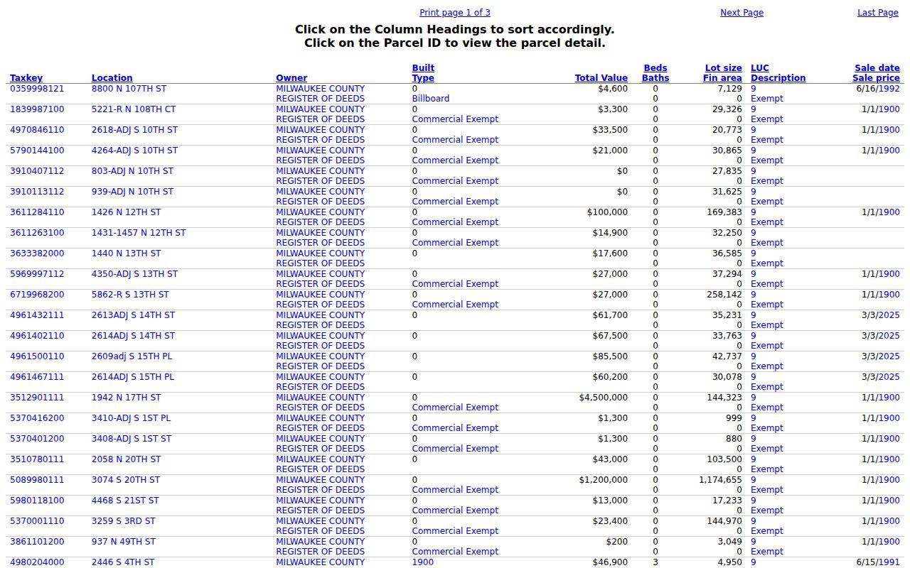
The image shows why ZIP is only the first filter. The tax key and situs point to one legal parcel, while owner and value fields answer property questions. They do not list every person at that address. For a deed, use the Milwaukee County Register of Deeds and the parcel's exact identifiers.
- ZIP code
- A five-digit postal routing zone that may cross municipal or neighborhood lines.
- ZIP+4
- A nine-digit code that narrows delivery to a smaller route segment, building, or group.
- PO-box ZIP
- A code used mainly or only for post-office boxes instead of street delivery.
- Unique ZIP
- A postal code assigned to a high-volume institution or organization.
- Carrier route
- The delivery path assigned to one mail carrier; it is smaller than a full ZIP.
Milwaukee's Former Borders and ZIPs
Modern postal lines can hide older municipal records. A present address may once have been in the Town of Wauwatosa, Town of Lake, North Milwaukee, Granville, or Bay View. Those former jurisdictions matter when a parcel search moves back in time. Tax rolls, plats, permits, or archives may be filed under the older place rather than today's Milwaukee mailing name.
The problem is sharp near 53213, 53214, 53220, 53226, 53227, and 53228. These areas touch Wauwatosa, West Milwaukee, West Allis, Greenfield, or Hales Corners geography. Postal labels and city limits answer different questions. Use ZIP for delivery, GIS for jurisdiction, and the tax key or legal description for land.
Milwaukee also changed almost all city address numbers in 1930 and changed many south-side street names. That event affects old parcel and directory work, even when the modern ZIP is correct. The city's address converter should be used before comparing a current parcel with an older street record.
Milwaukee ZIP Voter Data Limits
Wisconsin's statewide registration list includes a residential postal ZIP as a data element, but the public route is a written data request, not the MyVote form. Wis. Stat. § 6.36 permits access to nonprotected registration information. Date of birth, operator-license number, Social Security number, confidential-elector address, and accommodation indicators are withheld from general public access.
Under Wisconsin Administrative Code EL 3.50, an electronic report starts with a $25 base charge, adds $5 for up to 1,000 records and each further 1,000, and is capped at $12,500 for the standard electronic report. Paper is $0.25 per page plus delivery. Custom report costs can include programming, handling, reproduction, and maintenance.
A ZIP selection can summarize lawful public registration data, but it cannot identify every household member or reveal a ballot choice. Safe at Home participants may be confidential electors. Their true addresses must not be exposed or inferred from a surrounding parcel list.
Postal geography is not resident proof. Use Milwaukee ZIP results for lawful geographic research, and never use address data to stalk, harass, intimidate, or expose a protected person.
Milwaukee ZIPs Versus City Limits
A postal code is designed for delivery, while a city boundary defines government jurisdiction. That difference determines which assessor, permit office, election clerk, and municipal court holds a record. An address can use Milwaukee in the mailing line and still sit in Wauwatosa, West Allis, West Milwaukee, Greenfield, or another municipality.
Check three fields before choosing a custodian: the USPS standardized city and ZIP, the GIS municipality or city-limit layer, and the assessor's situs and tax key. If they point to different place labels, follow the actual parcel jurisdiction for city records. Use Milwaukee County sources when the record is kept countywide.
The Milwaukee postal directory therefore narrows geography without claiming a complete roster. Standard zones, border zones, and institutional codes each require a different level of care. Exact-address verification keeps a postal shortcut from becoming a mistaken resident claim.