
Walk Milwaukee Streets Parcel by Parcel
A useful Milwaukee street directory begins with land, not an assumed household list. Enter a complete street address in My Milwaukee Home to validate it and obtain the tax key. That number is the stable parcel identifier used to connect city records even when an address is typed several ways. Next, open the assessor result and note the owner, situs address, owner mailing address, property class, assessment figures, and sale date. The situs address is where the parcel sits. The mailing address is where tax correspondence goes, and the two may differ.
Then use Map Milwaukee to move along the block. Parcel outlines, house numbers, street names, ZIP labels, tax keys, and city limits turn a road into a sequence of properties. This street-by-street method shows ownership evidence, not a complete roster of residents. Deeds and reverse directories can extend the trail, while voter information is available only through the lawful state and local access channels.
- Validate the address through My Milwaukee Home and save its tax key.
- Check the City Assessor for the indexed owner, situs, mailing address, class, value, and sale date.
- Pan along the same road in Map Milwaukee and record the tax key for each parcel of interest.
- Follow ownership backward through the Milwaukee County Register of Deeds.
- For older occupants, use the library's address-order directories after converting any pre-1930 address.
Milwaukee Assessor Address Fields
The City of Milwaukee Assessor Real Property Search accepts an owner name or property address. Results expose the details needed to distinguish one parcel from another. A street directory result should preserve the source labels because “owner,” “mailing address,” and “situs” do not mean the same thing.
| Result field | What it means | Street-search use |
|---|---|---|
| Owner name | Indexed taxpayer or titled owner | Starting name for a deed search |
| Situs address | Location of the parcel | Confirms the street and house number |
| Tax key | City parcel identifier | Joins assessor, map, and DNS records |
| Property class | Recorded use or exemption class | Helps separate homes, duplexes, and exempt sites |
| Land, improvement, total | Assessment components | Describes the parcel, not its occupants |
| Sale or assessment date | Date displayed with the result | Points toward a likely deed period |
The live results also provide print and page controls. Values update annually in mid-April. For help, the Assessor's Office is in City Hall, Room 507, 200 E. Wells Street, and can be reached at 414-286-3651 on weekdays from 8:00 a.m. to 4:45 p.m.
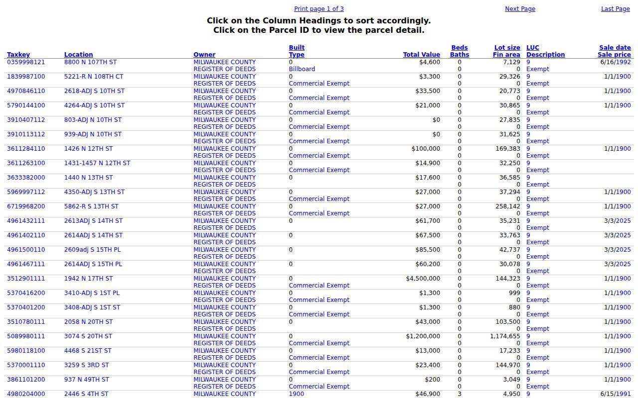
A representative assessor results screen shows how owner names, tax keys, situs addresses, classes, values, exemptions, and dates appear together.
Map Milwaukee Street Layers
Map Milwaukee supplies the visual part of a by-address search. The city's reference service includes parcel outlines, house numbers, tax-key labels, street names, ZIP boundaries, and city limits. Other available map applications cover zoning, census data, green infrastructure, and quarter sections. The old “I Want To” address and tax-key tools were removed, so use the search bar at the upper right.
Zoom until individual parcels and house numbers are clear. Select the target parcel, copy its tax key, and then click the lots beside it. County land data can add municipal, voting, school, legislative, and environmental boundaries. Those layers help when one road crosses from Milwaukee into a nearby municipality. They also prevent a neighborhood label from being mistaken for a legal boundary.
Open the city's Map Milwaukee hub before walking a road parcel by parcel.
Milwaukee Street Record Terms
Four terms recur when city addresses are matched with county land records. Their meanings keep the street directory from overstating what a record proves.
- Parcel
- A legally defined piece of land tracked under one tax key.
- Situs address
- The physical location assigned to the parcel, separate from the owner's mailing address.
- Plat
- A recorded map that identifies a subdivision, lot, and block.
- Criss-cross directory
- A directory arranged by street and house number rather than only by surname.
A tax key usually survives formatting differences better than a typed address. A legal description can remain useful even after a street number or name changes.
Milwaukee Tax Keys to Deed Chains
The Milwaukee County Register of Deeds turns a current parcel into an ownership history. Begin with the current owner's name, tax key, and legal description. Search for the purchase deed, note the grantor, then search that seller as a grantee to find an earlier purchase. Grantor means the party transferring an interest. Grantee means the party receiving it.
The archive contains digitized real-estate instruments back to 1835, but the method changes at April 1, 1948. Later deeds support grantor, grantee, tract, and document-number searches. Earlier deeds are digitized yet require a document number or book and page. Digital Reel, a tax-key grantor/grantee index maintained by the City Tax Assessor from the 1920s through 1989, can bridge part of that gap. Tapestry is not designed for complex historical research.
Remote Tapestry access is fee-based. County copies can also be requested at the counter or by mail. A mailed request should include the document type and number when known, full name, property address, phone number, certification request, and payment. Complex ownership studies require an appointment at least 24 hours ahead; staff guide researchers but do not conduct the search.
Search break. Before April 1, 1948, find a document number or book and page before expecting the digitized deed image to resolve a name search.
Milwaukee Permits by Street Address
The Department of Neighborhood Services Land Management System adds permits, complaints, orders, inspections, and attachments to a Milwaukee street search. Start through My Milwaukee Home because it validates the address and resolves the tax key. In the property details, the blue record number opens a case. Complaint identifiers may begin ENF, orders may begin ORD, and cleanup items may begin GBG.
Within a record, “Record Info” and “Attachments” can expose mailed violation documents. The inspections view contains comments and future inspection details. Permit microfiche for city-limit buildings constructed after 1888 may name an owner, architect, builder or contractor, and may give cost and a short work description. The Development Center at 809 N. Broadway keeps the microfiche channel. DNS warns that online records can lag and are not certified. A written Wisconsin Public Records Law request goes to the proper department custodian when an official copy or missing record is needed.
Note: A permit names people linked to work on a parcel, but it does not prove that any named person lived at the site.
Milwaukee's 1930 Address Trap
Almost every Milwaukee house number changed in 1930, and many south-side street names changed too. Cambridge Avenue was renumbered more than once. A pre-1930 street search can therefore miss the right parcel even when the old directory entry was copied correctly. The Historic Preservation Commission property-research guide links the address converter and explains the supporting tax, permit, directory, deed, census, and fire-map sources.
The converter has its own quirk: numbered streets are filed by spelled-out names. “Fiftieth,” “Fortieth,” and “Sixteenth” appear alphabetically, not in numeric order. Former Town of Lake, Town of Wauwatosa, North Milwaukee, Granville, and Bay View parcels add a second risk. Their older tax or municipal records may sit at the Milwaukee County Historical Society, Milwaukee Public Library archives, or City Records Center rather than under the modern address.
Milwaukee Records Indexed by Street
No single Milwaukee record supplies a full list of everyone at an address. The most reliable street directory method compares sources whose fields and access rules differ.
| Record Set | Keeper | What It Shows | Access |
|---|---|---|---|
| Property roll | City Assessor | Owner, situs, mailing address, tax key, class, values | Free web search and office help |
| GIS parcel map | City and county GIS | Parcels, house numbers, ZIP, city and district lines | Free map viewers |
| Deeds and plats | Milwaukee County Register of Deeds | Transfers, legal description, lot and block | Tapestry, Laredo, counter, mail, appointment |
| Voter records | Wisconsin Elections Commission and local clerks | Unprotected registration fields, not all residents | Self-lookup or written data request |
| Permits and cases | Milwaukee DNS | Permits, complaints, orders, inspections, attachments | Web search, microfiche, records request |
| Reverse directories | MPL and MCHS | Occupant or business by address from 1921 | Reference shelves, film, and staff help |
The tax key ties the assessor result to maps, permits, and land records. The street and number tie the parcel to later reverse directories. For the historical shelf itself, consult the Milwaukee city directory collections rather than treating one modern property result as a household history.
Milwaukee Voters Are Not Households
MyVote Wisconsin is a self-record checker. It asks for first name, last name, and date of birth, then lets the matched voter confirm “This is Me!” It is not a public by-street roster. A defined request for unprotected statewide voter data must be made in writing under Wisconsin law and may include a regulated fee.
Public registration data can include name, residential and mailing address when different, municipality, county, ward, districts, registration status, registration date, and elections in which the voter took part. It does not show ballot choices. Date of birth, driver-license number, Social Security number, protected addresses, and accommodation indicators are restricted. Safe at Home participants may also be confidential electors.
Note: A voter list omits children, nonregistered adults, and protected voters, so it cannot establish every member of a Milwaukee household.
Milwaukee Streets in Reverse Directories
Milwaukee Public Library and the Milwaukee County Historical Society hold address-order directories beginning in 1921. These volumes let a researcher start with a house number and find the printed occupant or business. They are especially useful when the assessor names an owner who did not live on the parcel. Earlier volumes are arranged by name, so an address-only search before 1921 needs help from deeds, permits, tax rolls, or a known surname.
The reverse-directory evidence is historical, not current. Record the volume year, exact printed spelling, page, and abbreviation key. Compare adjacent years to see whether a name persists or changes. For a pre-1930 entry, convert the number before pairing it with today's street directory and parcel map.
Limits of Milwaukee Street Records
A Milwaukee street directory cannot prove every person who lives in a building. The assessor identifies an owner or taxpayer. A deed records an interest in land. A permit may name the owner, architect, or contractor. Voter data includes registered voters within statutory limits, while a reverse directory captures what a publisher printed for one year. None is a complete household census.
Renters and other household members may never appear. Utility customer accounts are not a public street list, and motor-vehicle address data is restricted under the federal Driver's Privacy Protection Act and Wisconsin rules. Protected voter addresses and Safe at Home addresses must remain confidential. When a portal record seems wrong or incomplete, ask its custodian for the source record rather than filling the gap with an inference.
Lawful use. Use Milwaukee address records only for lawful personal research. Never use them to stalk, harass, threaten, expose a protected address, or harm anyone.